June 27, 2026
ROGII - Wellbore Geology Prediction
Predicting wellbore geology using deep learning.
Project Overview
—
Table of Contents
—
1. Introduction
This is essentially a geological correlation problem disguised as a machine learning competition.
1.1 What Happens During Drilling
Imagine you’re drilling a horizontal oil well. At first, the drill goes vertically downward; then it bends and continues horizontally for several kilometers.
The goal is not simply to stay underground. The goal is to stay inside a very specific geological layer that contains oil or gas. Rock layers stack above one another—sandstone, shale, a target reservoir, limestone, and so on. If the drill leaves the reservoir, production drops, money is lost, and additional drilling becomes necessary.
While drilling, engineers constantly ask: where exactly are we inside these geological layers?
1.2 Why Direct Observation Is Difficult
You cannot directly observe the rock. The drill is several kilometers underground. You only receive indirect measurements from sensors.
One important measurement is Gamma Ray (GR), which measures the natural radioactivity of the surrounding rock. Different rocks have different GR signatures—for example, sandstone tends toward low GR, shale toward high GR, and limestone toward medium GR. GR acts almost like a fingerprint of the geology.
1.3 The Typewell
Suppose you’ve already drilled another nearby well. That previous well is vertical. Along it, you know GR, the exact geology, and the geological formations at every depth. This becomes your reference well, called the Typewell.
The Typewell contains depth, GR, and formation labels. For that vertical reference, you know everything.
1.4 The Horizontal Well
For the horizontal well, the situation is harder. You know location (X, Y, Z), GR, and trajectory—but you no longer know exactly which geological layer you’re inside. That is exactly what must be inferred.
1.5 What TVT Means
This is the most confusing part. TVT does not mean physical depth underground. It is a geological coordinate: your position inside the geological stack.
Think of it like asking, “Where am I inside the geological cake?” Within a reservoir, TVT tells you your position from top to bottom. If TVT increases, the drill goes deeper in geological terms; if TVT decreases, it climbs upward; if TVT stays constant, the drill perfectly follows the layer.
TVT is simply your position in this geological coordinate system—not raw vertical depth.
1.6 Why Z Is Not Enough
Geology bends. Two wells at exactly the same vertical depth Z can sit in different layers: one inside the reservoir, the other already below it. Same Z, different geology. This is why TVT exists.
2. Data Description
2.1 Horizontal Well CSV
Every row corresponds to one foot of drilling. For each foot you know X, Y, Z, GR, and trajectory—and during training, TVT.
The important columns are:
- MD (Measured Depth): distance travelled along the well, not vertical depth. MD keeps increasing as the well progresses.
- X, Y, Z: actual 3D coordinates (East–West, North–South, depth).
- GR: the gamma ray measured at that point—the rock fingerprint.
- TVT: the answer—where you actually are in geology (training only).
- TVT_input: during training,
TVT_input == TVT.
In the test set, known fields remain known until a cutoff point; then TVT becomes NaN. That cutoff is called the Prediction Start (PS). Everything after PS must be predicted.
2.2 Typewell CSV
The Typewell contains TVT, GR, and Formation. For example, at successive TVT values you might see GR readings of 45, 48, 52, 51 alongside formation labels such as BUDA or EGFDL. This is the complete geological dictionary for the reference well.
2.3 Why the Typewell Helps
Suppose the horizontal well records a GR sequence such as 35, 37, 40, 55, 68, 82. You search the Typewell for a matching GR pattern—say, 34, 38, 41, 56, 69, 81 at TVT ≈ 1500–1505. The match suggests the drill is currently around TVT = 1500. This is geological correlation.
2.4 Known TVT Before the Prediction Start
Engineers have already interpreted the beginning of the well. Before PS, known GR maps to known TVT and the model can learn that relationship. After PS, GR is still observed but TVT is unknown and must be predicted.
3. The Machine Learning Task
3.1 Formulation
For each well:
Input: known trajectory, known XYZ, known GR, known Typewell, known TVT before PS.
Output: TVT after PS. Nothing else.
3.2 Why This Is Difficult
Several factors influence TVT: drill trajectory, geological dips, nearby formations, previous TVT trend, GR pattern, similarity with the Typewell, and neighboring wells. A simple GR-matching algorithm is often insufficient.
3.3 An Intuitive Picture
Think of hiking with a topographic map. The Typewell is the complete map. The horizontal well is your GPS trace. For the first half of the hike you know your altitude; for the second half your altimeter breaks. You still know GPS position, terrain texture, previous altitude, and the reference map. Your task is to reconstruct the missing altitude.
That is exactly what this competition asks—except “altitude” is replaced by TVT, a geological position within the rock layers.
4. Dataset
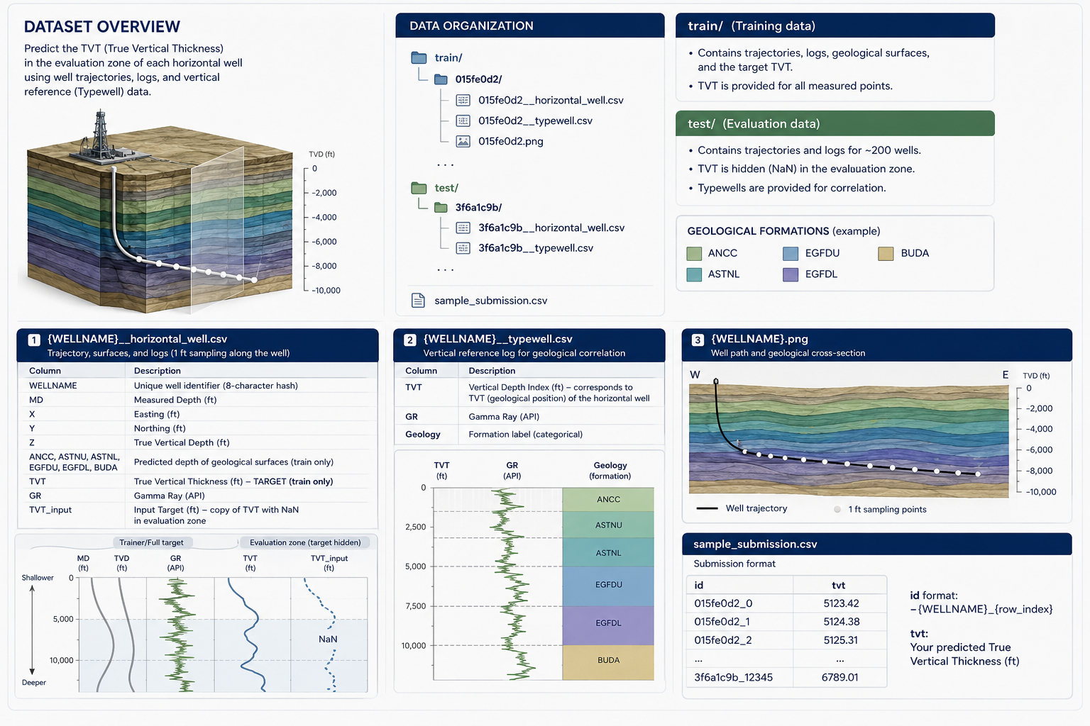
Dataset overview for the ROGII wellbore geology prediction task.